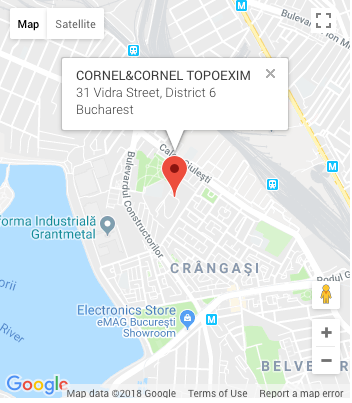
About us

ABOUT US

Cornel & Cornel Topoexim SRL is a Romanian company specialized in topography, cadastre, cartography – GIS, and geodesy services. SThe services and solutions provided are based on complex measurements and on processing and managing large volumes of data, in order to meet the multi-dimensional needs of customers.

Established in 1994 and thus having a 24-years experience on the Romanian market, Cornel & Cornel Topoexim SRL is currently one of the main providers of integrated solutions in the spatial data management and processing industry.

view more
WHY
US?

PROFESSIONALISM

Accuracy and precision in execution. We meet customer requirements and deliver solutions at the best quality-price-ratio.

INNOVATION

We develop technologies transposed into our services.

CONTINUOUS DEVELOPMENT

Good knowledge of legislation and changes on the market

INTEGRITY

We act with complete integrity and honesty in everything we do.

SERVICES

  • Implementation of cadastre for administrative-territorial units
  • Design and development of general and specialized cadastral systems at the macro and micro level
  • Cadastral measurements using state-of-the-art technologies
  • Creation of cadastral databases by using GIS applications
  • Development of cadastral plans at different scales
  • Development of cadastral registers/documentation
  • Consultancy and management of property registration
  • Creation of large scale topographic maps
  • Development of thematic maps (demographic, social, economic, forecasts, etc.)
  • Georeferencing and vectorization of old maps
  • Geospatial data acquisition (GIS)
  • Development of GIS applications
  • Implementation of personalized applications in various fields: environment, petroleum industry, transport, aviation, cadastre, historical monuments, etc.
  • Development and updating of geospatial databases
  • Digitization of plans and maps
  • GIS consultancy
  • Measurement and design of high-complexity GNSS networks
  • Development of permanent GNSS networks
  • Creation and expansion of local geodetic networks
  • Interconnection of national networks with those of the neighbouring countries
  • Drafting of flight plans and execution of photogrammetric flights
  • Determination and identification of pre-markers or benchmarks in photograms
  • Creation of orthophotoplans at various scales
  • Development of the digital terrain model
  • Volumetric calculations
  • Realizing the measurement in various areas:
    • Survey of already existing Power Lines with the aim of determining the condition of catenaries and of identifying possible obstacles
    • Survey of cross sections for road projects
    • Survey of railway lines with the aim of taking the inventory of all infrastructure components
    • Survey of roads with the aim of improving service ability
    • Survey of façades
    • Survey of industrial installations;
  • As built production for road and railway infrastructure
  • Monitoring trees growth
  • Monitoring excavations
  • Digital Surface Model (DSM)
  • Digital Terrain Model (DTM)
  • High-precision measurements
  • Determination of horizontal/vertical displacements of structures
  • Deformation monitoring
  • Monitoring of construction axes
  • Topographic support
  • Orthophographic maps (for extended surfaces)
  • Obstacle charting work
  • Airport GIS systems
  • Drawing works
  • Rescue - evacuation maps

CERTIFICATION

SC CORNEL&CORNEL TOPOEXIM SRL has the following certifications:

Projects

The developed projects demonstrate the company's ability to implement projects with complex requirements in various areas.

Expropriation executed for caile ferate

Rehabilitation of railway line Brasov - Simeria, part of Pan-European Corridor IV, for trains with a maximum speed of 160 km / h – Section: Sighisoara – Coslariu section for the administrative-territorial units (ATU): Valea Lunga, Blaj Municipality; Craciunelu Commune, Mihalt commune - LOT 1.

More

The registrul local green spaces - Bucharest

Realization of an unique system of evidence and inventory of green areas in capital
Obtaining the orthophotoplan of Bucharest municipality and the Digital Surface Model
Obtaining the 3D vector map and the multispectral recordings

More

OUR TEAM

Topoexim has qualified staff with solid knowledge in the field and rich professional experience. The constant participation of our specialists in major national and international projects offers the guarantee of high-quality services provided on time and with the accuracy demanded by the beneficiary.

The team is made up mostly of young professionals whose expertise is complemented by professionals with extensive experience in various fields of activity. All those involved have been formed at prestigious Romanian universities.

WHY CHOOSE US?

Because we provide the right combination of solutions for our customers, at the right time.

  • Accuracy and precision in execution
  • Extended access to a wide range of services
  • Latest technologies
  • Transparency
  • Compliance with customer needs, contractual deadlines, technical standards, and national regulations
  • Permanent contact with the main institutions in the field
  • Familiarity with the legislation and changes on the market

OUR CLIENTS

Topoexim partners are part of our success.

The customer portfolio includes: